Checkerboard Land Ownership
Patterns:
The Legacy of the Railroad
Land Grants
|
|
Each swath of checkered land |
|
|
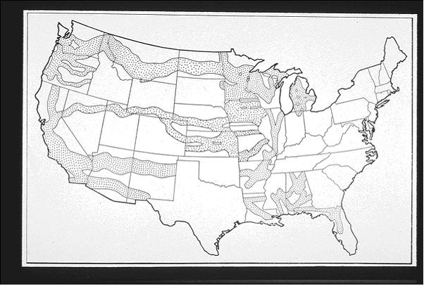
The end of the 19th Century saw one of the biggest public land giveaways in U.S. history, with the federal government agreeing to allow large railroads rights to use of huge tracts of federal lands for development of transnational railways. Prior to 1862, the grants were made via the state governments; nine states granted almost 49 million acres in railroad land grants. In 1862, with the advent of the interstate transcontinental railroads, the federal government began making the grants directly to railroad corporations (Jehnsen 1995). In 1864 President Lincoln signed into law the largest of the railroad land grants, the Northern Pacific railroad land grant .
Three quarters of all railroad grant lands were eventually gathered under the four railroads: the Northern Pacific (40 million acres), Santa Fe (15 million acres), Southern Pacific (18 million acres), and Union Pacific (19 million acres). In 1995 and 1996, after more than a century of acquiring and consolidating dozens of smaller railroads, these four railroads were merged into two: the Burlington Northern Santa Fe and the Union Pacific (which had acquired the Southern Pacific).
The checkerboard pattern of the land grants had begun during the canal land grant era, and continued with the railroad grants as a concession to opponents both of land subsidies and of interstate railroads. Land grant proponents compromised by agreeing to grant every other square-mile section of land to the railroads. The rationale for this was that the government's sections would double in value because of their proximity land sales to the railroad, and thus the government would lose no revenues from its own land sales. This created a "checkerboard" pattern of ownership that is still visible on maps of many Pacific Northwest forests (Williams 1992).
The railroad land grants covered ten percent of the continental United States, yet because of the corridor and checkerboard patterns of the grants, their influence extends considerably beyond that (Jehnsen 1995). It has been estimated that railroad corporations controlled almost one-third of the country, and an even greater portion of the American West, where most of the land grants were located. Even today, the largest land owners in many Western states are still the land grant railroads and their corporate heirs (Oregonians for Labor Intensive Forest Economics 1998).
Often, large corporations have built their empires, their profits and their environmentally destructive legacy by buying illegally acquired public property at land grab rates and destroying these lands through excessive logging. Clearcuts spanned all the way from Yellowstone Park to Seattle, Washington. These practices have endangered or destroyed hundreds of species of plants and animals that rely on native forests for their survival. Environmental impacts from over cutting include erosion and intrusive sedimentation into water ways, flooding due to increased water yield, damaged fisheries, habitat fragmentation, damage to native fauna and flora, stunted regeneration and pest epidemics including Boll weevils, Spruce Bud worms, Mountain pine beetles and many others (Manning 1988, Nehlsen 1991, Rhodes 1991).
The various homestead laws and surveying
methods also set up a pattern of ownership based on square land units that, for
the most part, did not fit with the contours of the land. As the public domain
has filled, millions of farms and ranches have created an enormous checkerboard
of private ownership across the country, making ecosystem management almost
impossible.
References:
Jehnsen, Derek et al. Railroads and clearcuts:
legacy of congress? 1864 Northern Pacific railroad land grant. 1995.
Manning, Richard. Logging outstrips growth: observers warn of effects on environment, industry. Missoulan, Oct 16, 1988.
Nehlsen, Willa, Jack E. Williams and J. Lichatowich. Pacific Salmon at the crossroads: stocks at risk from California, Oregon, Idaho, and Washington. Fisheries 16(2): 4-21 March/April 1991.
Oregonians for Labor Intensive Forest Economics A history of Mismanagement <http://www.efn.org/~olife/chp2.1.html
Railroads and Clearcuts: Chronology of the
Northern Pacific& Related Land Grant Railroads
http://www.endgame.org/rrcc-history.html
Rhodes, Jon and Richard Jones. Riparian area managment: current management situation and the need for improved riparian managment. Memorandum to Clearwater National Forest Supervisor in reply to 2526, Dec. 19, 1991.
Williams, Gerald W. 1992a "John B.
Waldo and William G. Steel: Forest Reserve Advocates for the Cascade Range of
Oregon." Pp. 314-332 in Harold K. Steen's (ed.) The Origins of the
National Forests: A Centennial Symposium. Durham, NC: Forest History Society.